What Is the State of This Parcel?

Tarımus reads the past, explains the present, and makes the future visible.

Agricultural Decision Infrastructure · Evidence from Parcels to PortfoliosExplore
30+
analysis methods
81
provinces nationwide
20M+
parcel data pool
200+
crop taxonomy
We Speak the Framework You Work In
TSRSIFRS S2EUDRGHG Protocol

We Move Farming Decisions from Guesswork to Proof.

Method
30+ analysis methods · satellite, climate, soil, land
Scale
Parcel → village → district → province → portfolio
Framework
TSRS · IFRS S2 · EUDR · GHG Protocol
Delivery
Natural language · PDF · Excel · API · dashboard

Food companies, exporters, banks, insurers, cooperatives, ESG advisors — everyone hits the same gap: the real climate risk and sustainability profile of their sourcing regions stays invisible in any structured, reportable form.

Tarımus reads every parcel together with its history, its current development, its standing relative to its surroundings, and the climate risks it is exposed to. A single field and a sourcing region of tens of thousands of parcels are assessed at the same depth; the result scales from village to region to portfolio.

Our purpose is singular: to turn fragmented farmland into a measurable foundation where institutions can make the right decision on scientific ground — and nature comes out ahead.

Why Tarımus?
  • TSRS-aligned
  • Parcel-scale
  • Provable
  • Portfolio-scale
  • IPCC-based
  • Sustainability
  • Supply chain
  • Türkiye-scale

From Parcel to Portfolio — the Same Precision.

Tarımus assesses a single parcel and a sourcing portfolio of tens of thousands of parcels at the same depth — one consistent reading from parcel to region, region to portfolio.

Parcels that aren't in the data pool, or that are added later, are folded into the same framework instantly; your existing sourcing areas and new ones are managed under a single reporting standard.

  1. Parcel

    It All Starts Here

    Every parcel is read together with its crop, season, climate risk and water indicators — alongside its own history.

  2. Region

    From Village to Region

    Parcel results merge at village, district, province and regional scale; one consistent picture at every level.

  3. Portfolio

    Institutional Scale

    The risk, water and production signal of thousands of parcels is compared on a single dashboard; it becomes an enterprise risk map.

  4. Report

    Decision-Ready Output

    You query all of this data in plain language; it returns as reasoned, fully sourced output in PDF, Excel, API and dashboard form.

Capabilities

One Parcel,
30+ Analysis Methods.

We process the same parcel data with methods established in academic literature and accepted internationally; from crop verification to yield forecasting, from drought to carbon, we turn dozens of analyses into a report in one click.

Explore the Platform
  • History & Inventory

    • Crop type classification
    • Planting and season history
    • Land change detection
    • Idle / abandoned land detection
  • Current Status

    • Parcel health & anomaly
    • Precise phenology (BBCH)
    • Soil moisture & minerals
    • Soil organic carbon (SOC)
  • Risk & Early Warning

    • Drought & water stress
    • Frost & extreme weather damage
    • Disease & pest outbreak
    • Flood / inundation exposure
  • Forecasting & Simulation

    • Harvest / yield forecasting
    • Production & credit scoring
    • Crop growth simulation
    • Regenerative input impact simulation
Institutional Value

One Analysis, Two Gains.

Tarımus's scientific analysis becomes a different kind of value depending on what an institution needs: audit-ready reporting for some, measurable returns in the field for others. Because the source and accuracy of every output are clear, it gives you firmer ground whatever the purpose.

Compliance & Reporting

Audit-Ready Institutional Reporting

A reporting layer that fills TSRS, IFRS S2, EUDR and physical climate-risk disclosures with real field data from your sourcing regions — traceable all the way back to its source.

  • TSRS & sustainability reporting
  • Physical climate & production risk
  • Scope 3 / carbon starting point
Compliance Solutions

Operational Return

Measurable Returns in the Field

Parcel health, water and input efficiency, yield forecasting and early warning — decisions that recur throughout the season raise yield, cut water and input costs, and secure supply.

  • Parcel health & yield monitoring
  • Water and irrigation efficiency
  • Supply monitoring & early warning
Operational Solutions
Live product · app.tarimus.com

01 · Türkiye

All of Türkiye, One Map

20M+ parcels · 81 provinces

02 · Konya

Thousands of Crop Patterns

1.6 million+ parcels — from rice to cotton, colored parcel by parcel

Sustainability

Those Who Respect the Land
Endure.

The future of farming depends on water, climate and soil. Most of the world's fresh water flows to agriculture, food systems generate roughly a third of global greenhouse gas emissions, and a warming climate is already cutting yields. Tarımus measures water, climate vulnerability and carbon at parcel scale with scientific methods — so institutions can truly understand and protect their sourcing regions.

Water Indicators — Green/Blue/Grey

Rain-fed use, irrigation dependence and pollution pressure, paired with a water-efficiency score and irrigation priority.

Climate Vulnerability — IPCC-Based

Hazard, exposure, sensitivity and adaptive capacity in one framework, mapped to a low/medium/high/critical vulnerability band.

Carbon — Baseline and Readiness

A kgCO₂e breakdown and a reduction-readiness score. Not a certificate — a readiness layer aligned to the GHG Protocol, IPCC and Verra frameworks.

Soil & Land Health

Soil organic carbon, erosion tendency and land-use change — the foundation of productivity and long-term carbon storage.

Book a Call
Parcel-patterned farmland
Why Tarımus

More Than
an Agtech Company.

  • Aerial view of farm parcels

    Analysis That Knows Its Region

    Satellite data is the same for everyone; the difference comes from knowing a region's crop calendar, climate regime and soil. Rice in Konya and cotton in Çukurova, for instance, are read through regional phenology — not a single generic model. We read every parcel together with its own history and surroundings, and measure risk against the conditions specific to that parcel.

  • Precision-farming technology

    The Latest Science and Methods

    We apply methods established in the academic literature and internationally recognized, along with current compliance procedures, in depth. Our accuracy advances with the latest developments in the field.

  • Sustainable irrigation

    The Right Decision, Backed by Data

    Which crop suits your region best, which parcel is at risk, where water should go first? We back your decision with parcel-specific data and its rationale, not guesswork.

Farmland parcelAt parcel scale
“The world takes its food from the soil — yet for too long we managed that soil by guesswork. When we make farming measurable with science, decisions that both secure production and protect nature become possible. That is why we built Tarımus.”

Ömür Karabulut

Founder · Tarımus

Meet the Team
Example Scenario

Same Data, Different
Institutional Decisions.

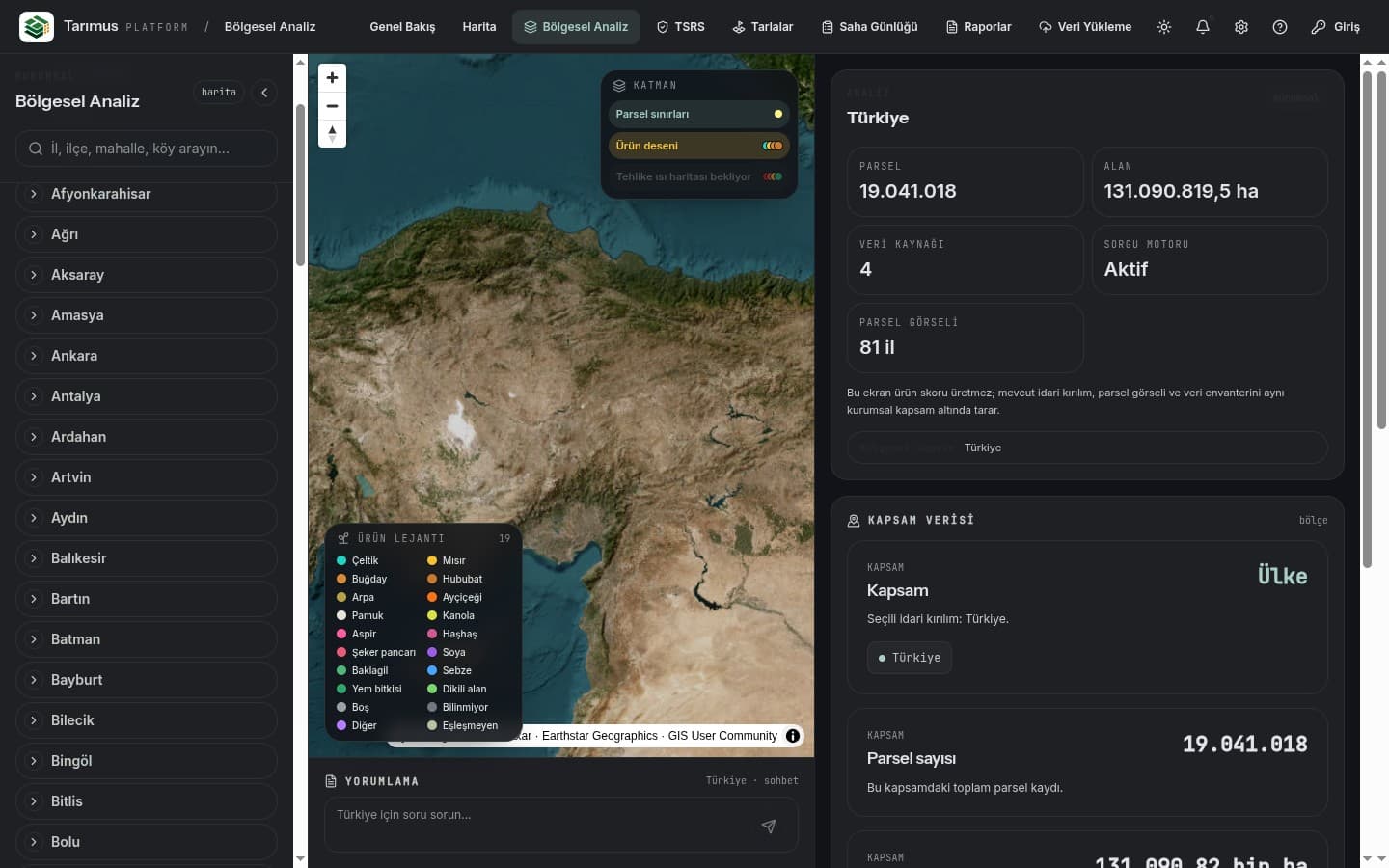
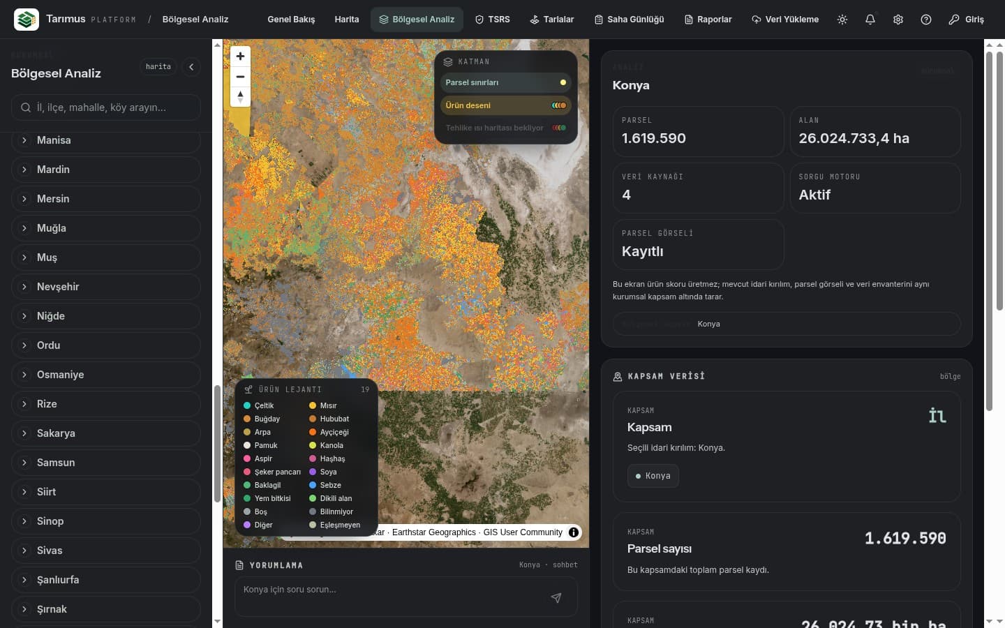
Food company · sourcing + compliance

A food company buying from hundreds of producers sees mid-season which sourcing regions are under drought or frost; it plans procurement ahead, lowers loss and disruption risk — and backs its sustainability disclosures with real field data.

Who It's For

Bank · insurance · portfolio

An institution carrying an agricultural credit or insurance portfolio sees at a glance which regions sit under physical climate risk, and grounds its decisions in what's actually happening on the ground.

All Solutions

Invitation

Let's Write the Next Chapter of Agriculture Together.

Food company, exporter, bank, insurer, cooperative or ESG advisor — let's talk through a pilot report for your sourcing region or portfolio. We'll listen, and we'll show you.

VerifiableTSRS-alignedSustainable